in the panel's header. (To switch back to
the alerts list, click the list button
in the panel's header. (To switch back to
the alerts list, click the list button  .)
.)When the selected a group is Geography, or any of its subgroups such
as a state in the United States, you can view the locations of the group's
alerts on its corresponding map, viewable on the Alerts panel. To switch
to the alerts map, click the map button in the panel's header. (To switch back to
the alerts list, click the list button .)
NOTE: You can filter the map by clicking the down arrow beside "Alerts" to open a menu of alert status indicators (see Alerts panel in Group view). From there, select the specific status by which you want to filter the map.
When viewing a map, look at both the general placement of alert symbols
 and the number of alerts indicated in the Alerts panel's header:
Alert
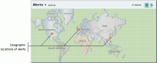
symbols are placed on a group's map at the latitude and longitude coordinates
associated with its children (i.e., its subgroups and devices). For example,
assume there are devices located in New York State in Buffalo and Schenectady,
both of which have an alert. Were you to look at the New York map, you
would see two alert symbols, one on or near Buffalo and one on or near
Schenectady; these locations are being derived from each device’s
latitude and longitude coordinates. By contrast, were you to look at the
U.S. map, you would see one alert symbol generally centered over New York
state; that alert symbol’s location is being derived from the latitude
and longitude coordinates of the New York group. In order to determine
the actual physical location of a device with an alert, set the context
to that device, as described below.
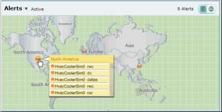
There will not necessarily be a match between the number of alerts indicated in the Alert panel's header and the number of alert symbols because some of the symbols may serve multiple alerts. For example, the Alerts panel's header in the first figure below (which illustrates the map for the World group) indicates nine alerts, but only three alert symbols appear. To see how many alerts are represented by a single alert symbol, click directly on it to reveal a list of devices with alerts (second figure below). You can further see exactly what event triggered an alert for an individual device by hovering the pointer over the box preceding the device’s name on the list (third figure below). (At this point, you can go directly to the device, that is, set the context to it, by selecting it on the list of devices with alerts.)
Map view of the Alerts panel in Group view for the World group
|
To see how many alerts are represented by a single alert symbol, click directly on it to reveal a list of devices with alerts.
List of devices whose alerts are represented by an alert symbol |
|
|
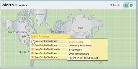
You can further see exactly what event triggered an alert for an individual device by hovering the pointer over the box preceding the device's name on the list. (At this point, you can go directly to the device, that is, set the context to it, by selecting it on the list of devices with alerts.)
Event details for the alert on a specific device |
|
|
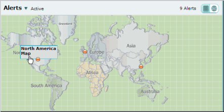
You can "zoom in" to the next lower group level by clicking anywhere on a geographic location (except on its alert symbol). When you do so, you will see text such as "North America Map". Click the text, and the map will change to that geographic location. You can continue zooming in with this technique until you arrive at the lowest-level geographic map.
Zooming in on a geographic location |
|